Short facts about South Sudan
| Continent | Africa |
| Coordinates | 05°N 31°E / 5°N 31°E |
| Total area | 619,746 square kilometres |
| Bordering countries | Republic of Sudan
The Central African Republic Ethiopia Democratic Republic of Congo Uganda Kenya |
| Highest point | Kinyeti, 3,187 metres above sea level |
| Longest river | The White Nile |
Borders
South Sudan is a land-locked nation with land borders to six other nations. It borders Sudan in the north, Ethiopia in the east, Kenya, Uganda and Congo to the south, and the Central African Republic to the west.
Total land borders:
- Republic of Sudan (1,937 km)
- Ethiopia (883 km)
- Central African Republic (682 km)
- Democratic Republic of Congo(628 km)
- Uganda (435 km)
- Kenya (232 km)
Ecoregions
South Sudan chiefly consists of tropical forests, swamps and grasslands. The White Nile passes through the country, and roughly half of its water goes into the country’s swamps or is consumed by animals.
The following terrestrial ecoregions, as defined by the Worldwide Fund for Nature (WWF), are present in South Sudan:
Tropical and subtropical moist broadleaf forests
- East African montane forests
Tropical and subtropical grasslands, savannas, and shrublands
- East Sudanian savanna
- Northern Acacia-Commiphora bushlands and thickets
- Northern Congolian forest-savanna mosaic
- Sahelian Acacia savanna
- Victoria Basin forest-savanna mosaic
Flooded grasslands and savannas
- Saharan flooded grasslands
Montane grasslands and shrublands
- East African montane moorlands
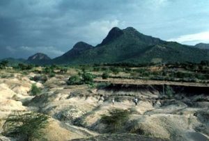
Notable mountains in South Sudan
The Imatong Mountain Range
The Imatong Mountain Range is located in the south-eastern part of South Sudan and continues into Uganda. This mountain range features dense montane forests and is home to a diverse flora and fauna, although forest clearance and subsistance farming has led to extensive erosion of the steep slopes during recent years.
Mount Kinyeti
 Mount Kinyeti, the highest mountain in all of South Sudan, is a part of the Imatong Mountain Range. The top of this mountain is 3,187 metres above sea level. The prominence is 2,120 metres.
Mount Kinyeti is found within Ikwoto County in the Imatong State, close to the border to Uganda.
The lower reaches of Mount Kinyeti forms the northernmost part of the East African montane forest ecoregion. If you continue further up to higher elevations, you will encounter montane grassland, scattered scrubs and hardy herbs that grow in rock crevices.
Mount Iro
Mount Iro is a 1,091 metre tall mountain. Just like Mount Kinyeti, this mountain is located in the Imatong State of South Sudan.
Mount Abourasséin
Mount Abourasséin is a 1,113 metre tall mountain located on the border between South Sudan and the Central African Republic (CAR). This means that it is included in both the Western Bahr el Ghazal state of South Sudan and the Haute-Kotto prefecture of CAR.
Lakes
Lake No and Lake Ambadi are two important lakes in South Sudan.
Lake No (coordinates: 9°29′52″N 30°27′54″E) is located just north of the Sudd swamp, at the confluence of the rivers Bahr al Jabal and Bahr el Ghaza. Lake No’s primary outflow is the White Nile. When Lake No is at its largest, it has a surface area of roughly 100 sqaure kilometres.
Lake Ambadi (coordinates: 8°42′N 29°19′E) is a par of a very large wetland area and is famous for its thriving colony of Shoebills (Balaeniceps rex).
Wetlands
Examples of large wetland areas in South Sudan are Sudd, Bahr el Gahazal, the Sobat River wetlands, and the Machar Marshes.
Rivers
Examples of important rivers in South Sudan
| River | Information |
| The Nile | Flows into the Republic of Sudan and eventually into Egypt, where it empties into the Mediterranean. |
| The White Nile | One of the two main tributaries of The Nile.
South Sudan’s capital Juba is located on the banks of the White Nile. |
| Sobat River | The most southerly of the great eastern tributaries of the White Nile, before the White Nile joins the Blue Nile.
The white sediment from the Sobat River is what gives the White Nile its name. |
| Bahr el Zeraf
(Water of the Giraffes) |
An arm of the White Nile in the Sudd region of South Sudan. |
| Bahr el Gazal
(Water of the Gazelles) |
Flows through the Sudd and into Lake No before joining the White Niile.
Bahr el Gazal is the main western tributary of The Nile. |
| Aswa River | Enters South Sudan from Uganda. |
| Koss River | Flows into a marshland |
| Kidepo River | Flows into a marshland |
| Medikiret River | Flows into a marshland |
| Kibish River | Flows into a Lake Turkana in years when the river has enough water to reach the lake.
This river forms the border between South Sudan and Ethiopia. |